Hydrographic surveying plays a vital role in maritime navigation, offshore infrastructure development, environmental monitoring and naval operations. By measuring water depths, mapping seabed features and collecting information about the underwater environment, hydrographic surveys provide the data needed to understand and operate safely within the marine environment.
Traditionally, these surveys have relied on crewed vessels equipped with specialist sonar and positioning systems. However, advances in artificial intelligence (AI), marine autonomy and sensor technology are changing how hydrographic data can be collected.
Autonomous hydrographic survey operations use uncrewed vessels, intelligent navigation systems and specialist survey equipment to collect seabed data with reduced reliance on personnel aboard the vessel. By combining autonomous surface vessels (ASVs) with AI-enabled mission management, operators can undertake repeatable survey missions, optimise data collection and extend their operational capabilities.
For organisations working in offshore energy, maritime defence, port management and marine research, autonomous surveying offers opportunities to improve efficiency, enhance safety and support more flexible survey operations.
What Is an Autonomous Hydrographic Survey?
An autonomous hydrographic survey is the collection of water-depth measurements, seabed information and other marine environmental data using vessels capable of carrying out some or all of their operational tasks without continuous direct human control.
These operations typically use an autonomous surface vessel (ASV) equipped with hydrographic instruments, navigation sensors and an autonomy system.
The vessel follows a planned survey mission, collecting measurements across a defined geographical area. Depending on its level of autonomy and the operating environment, it may also adjust its route, respond to detected obstacles and communicate operational information to a remote control centre.
Importantly, autonomous surveying does not necessarily mean removing humans from the process.
Hydrographic specialists remain responsible for survey planning, data quality, processing and interpretation, while remote operators may supervise vessel movements and intervene when necessary.
The principal difference is that the vessel can undertake many routine navigation and mission-execution tasks autonomously, reducing the need for personnel to remain physically aboard throughout the operation.
How Do Autonomous Surface Vessels Map the Seabed?
Autonomous hydrographic surveying combines established measurement technologies with advanced vessel navigation and mission management systems.
The process involves several interconnected stages.
1. Survey Planning and Mission Definition
Before deployment, survey specialists define the area to be surveyed, the required data quality, the survey equipment and the operational constraints.
A survey plan may include a series of parallel tracks, often described as survey lines, designed to provide the required seabed coverage.
The spacing between these lines depends on factors such as water depth, sonar swath width, seabed characteristics and the required survey standard.
Autonomous mission planning systems can help execute these routes consistently and may support adjustments when operational conditions change.
AI-enabled planning can also assist in evaluating navigational constraints and selecting appropriate vessel movements, although the extent of automated optimisation depends on the system’s capabilities.
For more detail on the underlying technology, see AI Route Planning for Autonomous Vessels: How Intelligent Navigation Optimises a Voyage.
2. Autonomous Navigation
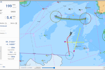
Once the mission begins, the vessel must navigate accurately while maintaining the planned survey track.
Autonomous navigation systems combine positioning information with data from onboard sensors to estimate the vessel’s location, heading, movement and surrounding conditions.
Depending on the installation, these systems may incorporate:
- Global Navigation Satellite Systems (GNSS) for positioning.
- Inertial navigation sensors for measuring motion and orientation.
- Radar and cameras for detecting nearby vessels and obstacles.
- Automatic Identification System (AIS) data for identifying cooperating vessels.
- Environmental information to support safe navigation.
AI-enabled autonomy software can interpret relevant sensor inputs and support navigational decisions, helping the vessel maintain its intended route while responding to changing circumstances.
Maintaining an accurate survey track is particularly important because inconsistent coverage can create gaps in the collected data or require sections to be surveyed again.
Marine AI explores the wider principles of this technology in How Autonomous Surface Vessels Navigate Without a Crew.
3. Hydrographic Data Collection
The survey vessel carries specialist instruments that measure the underwater environment.
One of the most widely used technologies is the multibeam echo sounder (MBES).
A multibeam echo sounder transmits acoustic pulses into the water and measures their return from the seabed. By combining the travel time of these signals with information about sound speed, vessel position and motion, survey systems can calculate seabed depths across a swath beneath the vessel.
Other survey instruments may include:
Single-beam echo sounders: Used to measure water depth directly beneath the vessel along its track.
Side-scan sonar: Produces acoustic imagery that helps identify seabed features, objects and changes in seabed texture.
Sub-bottom profilers: Use acoustic signals to investigate sediment layers and geological structures beneath the seabed.
Sound velocity sensors: Measure acoustic propagation conditions needed to correct sonar observations.
Motion reference units: Measure vessel movement, including roll, pitch and heave, helping correct survey measurements.
The exact payload depends on the survey objectives, vessel size and operating environment.
While autonomy software controls or assists with vessel operations, hydrographic instruments perform the measurements. Accurate seabed mapping therefore depends on both reliable vessel navigation and correctly configured survey equipment.
4. Data Processing and Quality Assurance
After collection, hydrographic measurements must be processed and validated before they can be used for navigation, engineering or scientific purposes.
Processing may involve correcting for vessel motion, sound velocity, positioning errors and water-level variations.
Survey specialists also examine data coverage, identify anomalies and assess whether the measurements satisfy the required quality standards.
AI and machine learning can assist with selected processing tasks, such as identifying unusual measurements or classifying seabed features. However, these functions are separate from autonomous vessel navigation and do not eliminate the need for appropriate hydrographic quality assurance.
For safety-critical applications, particularly nautical charting, data must meet the applicable survey specifications and undergo the required verification procedures.
How AI Improves Autonomous Hydrographic Survey Operations
Artificial intelligence has the potential to improve hydrographic surveying by making the vessel more responsive to its operating environment.
Rather than simply following a fixed sequence of waypoints, an AI-enabled autonomous vessel can use available information to support decisions about navigation, mission execution and operational safety.
Intelligent Obstacle Detection and Avoidance
Hydrographic surveys may take place in busy coastal waters, ports, offshore construction areas or locations where other vessels are operating.
An autonomous survey vessel must be able to recognise relevant navigational hazards and respond appropriately.
AI-enabled perception systems can combine information from radar, cameras, AIS and other sensors to develop a more comprehensive understanding of nearby activity.
This process, known as sensor fusion, helps the autonomy system assess potential collision risks and support appropriate manoeuvres.
Where necessary, the vessel may need to deviate from its survey track to maintain safe separation from another vessel.
Any interruption to the survey must then be accounted for to avoid leaving gaps in seabed coverage.
Marine AI examines these principles in Sensor Fusion for Autonomous Vessels: How AI Builds Situational Awareness at Sea.
Adaptive Mission Execution
Conditions at sea can change throughout a survey.
Wind, waves, currents, vessel traffic and equipment performance may all influence how effectively a planned mission can be completed.
Advanced autonomy systems can support mission adjustments based on changing operational conditions, subject to the system’s design and the limits established by its operators.
For example, a vessel may need to adjust its speed to maintain suitable survey data quality or alter its route temporarily to avoid another vessel.
In more sophisticated implementations, mission management systems may support rescheduling incomplete survey lines or identifying areas that require additional coverage.
These capabilities can help reduce unnecessary vessel movements and improve the consistency of survey operations.
Continuous Situational Awareness
Autonomous vessels depend on an accurate understanding of their surroundings.
This involves more than knowing the vessel’s geographical position.
An autonomy system may need to interpret the movements of other vessels, assess potential hazards, monitor navigational constraints and evaluate whether the current mission remains safe to execute.
AI-enabled situational awareness helps bring together these different information sources.
However, the effectiveness of the resulting decisions depends on sensor performance, environmental conditions, system validation and the operating limitations of the vessel.
What Are the Benefits of Autonomous Hydrographic Surveying?
Autonomous surveying offers several potential operational advantages over conventional crewed approaches.
Reduced Exposure of Personnel to Offshore Hazards
Marine surveying can involve operating in challenging weather, shallow waters, remote locations and areas with significant vessel traffic.
Uncrewed survey vessels reduce the requirement for personnel to be physically aboard the survey platform.
This can lower exposure to some operational hazards, although safe deployment, recovery, maintenance and remote supervision remain essential.
Improved Operational Efficiency
Smaller autonomous vessels may require fewer onboard resources than larger crewed survey platforms.
Depending on the mission, they can offer advantages in fuel consumption, logistical requirements and operational flexibility.
Autonomous navigation also supports consistent execution of planned survey lines, which can be particularly useful for repetitive data collection.
However, efficiency gains must be evaluated against the complete operation, including support vessels, communications, equipment servicing and data processing.
Repeatable Survey Missions
Some hydrographic applications require the same area to be surveyed repeatedly.
Examples include monitoring sediment movement, assessing changes around offshore infrastructure and tracking seabed conditions in ports and waterways.
Autonomous vessels can follow predefined survey routes with consistent navigational control, supporting repeatable data collection.
This can make it easier to compare measurements collected at different times, provided that appropriate survey methods and quality controls are maintained.
Greater Operational Flexibility
Uncrewed vessels can support surveys in locations where deploying a conventional crewed vessel may be difficult, expensive or operationally inefficient.
Smaller platforms may be particularly useful in shallow coastal environments or confined survey areas, subject to their draught, equipment and operating limitations.
They may also complement larger survey vessels, allowing organisations to select different platforms for different tasks.
Potential for Multi-Vessel Operations
Autonomous technology creates opportunities for multiple survey vessels to operate within a coordinated mission.
Rather than relying on one vessel to cover an entire area, separate platforms could be assigned different survey sections.
Coordinated mission management may improve coverage rates and provide additional flexibility, particularly for large survey areas.
However, multi-vessel operations introduce further requirements for communications, deconfliction, task allocation and supervision.
The feasibility of supervising multiple vessels depends on the autonomy system, operating environment, regulatory requirements and the capabilities of the remote operations team.
Applications of Autonomous Hydrographic Surveying
Autonomous hydrographic survey technology has applications across several maritime sectors.
Offshore Wind and Marine Energy
Offshore renewable energy projects require detailed information about seabed conditions during planning, construction and ongoing operations.
Hydrographic surveys can support cable-route assessments, infrastructure monitoring and the identification of seabed changes around offshore installations.
Autonomous surface vessels may provide a flexible way to undertake repeat surveys and collect data in operational areas.
Ports, Harbours and Coastal Infrastructure
Ports and harbours require reliable depth information to support safe vessel navigation and infrastructure maintenance.
Sediment movement, dredging activity and changes in seabed conditions can affect navigable water depths.
Autonomous hydrographic surveys can contribute to routine monitoring programmes, helping port authorities and survey providers identify areas requiring further investigation.
Environmental and Scientific Research
Marine researchers use hydrographic information to study seabed habitats, sediment movement and changes in coastal environments.
Autonomous vessels can support repeated measurements and potentially reduce the logistical burden of certain research missions.
They may also carry complementary scientific instruments to collect environmental data alongside hydrographic observations.
Maritime Defence and Naval Operations
Hydrographic information is important for naval navigation, operational planning and understanding the maritime environment.
Uncrewed survey vessels can support the collection of bathymetric and environmental information while reducing the need to deploy personnel aboard the survey platform.
Depending on the mission, autonomous surveying may contribute to maritime situational awareness, operational preparation and the assessment of strategically important waters.
These applications form part of the wider development of naval autonomy and uncrewed maritime defence operations.
The Role of Remote Operations in Autonomous Surveying
Although an autonomous survey vessel may undertake significant portions of its mission independently, human oversight remains an important part of the operating model.
A remote operations centre can provide personnel with access to vessel status, position, mission progress and relevant sensor information.
Depending on the system and communications available, operators may be able to modify mission parameters, respond to alerts or assume direct control.
Remote supervision is particularly important when a vessel encounters a situation outside its validated autonomous operating capabilities.
Communications availability also influences how an autonomous vessel can be operated.
Where connectivity is limited or interrupted, the vessel must follow appropriate pre-established procedures, which may include continuing within defined constraints, entering a safe operating state or taking another approved action.
The relationship between autonomous decision-making and human oversight is explored in Remote Operation Centres: How Autonomous Vessels Are Controlled from Shore.
Marine AI and the Future of Autonomous Survey Operations
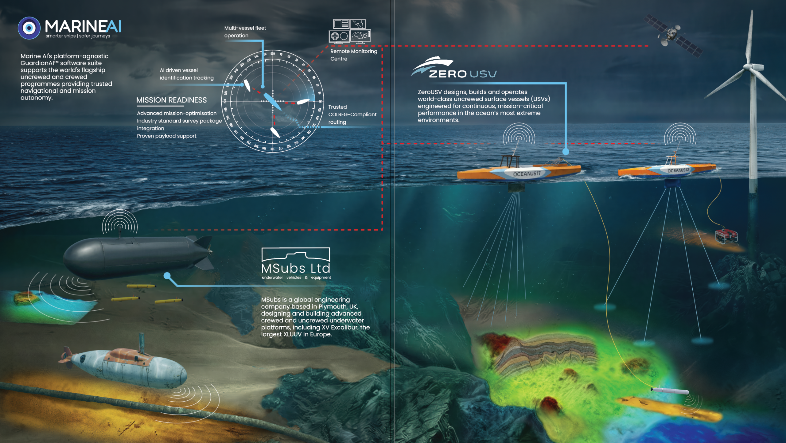
Marine AI develops autonomy technology designed to support intelligent uncrewed vessel operations.
Its GuardianAI autonomy system provides capabilities relevant to autonomous navigation, situational awareness, mission execution and vessel control.
These capabilities can support the operation of uncrewed surface vessels across a range of maritime applications, including hydrographic and scientific surveying.
By integrating autonomy technology with suitable vessel platforms and specialist survey payloads, operators can develop systems capable of undertaking survey missions with reduced reliance on continuous manual vessel control.
Marine AI’s approach reflects a broader shift towards adaptable maritime autonomy, where intelligent software can support different vessel types and operational requirements.
The objective is not simply to remove personnel from a vessel, but to enable safer, more flexible and more efficient maritime operations while retaining appropriate human supervision.
Further information about Marine AI’s autonomy technology is available at Marine AI.
Challenges and Considerations for Autonomous Hydrographic Surveys
Despite the potential advantages, autonomous hydrographic surveying presents several technical and operational challenges.
Survey accuracy: Autonomous navigation does not automatically guarantee hydrographic data quality. Sensor calibration, positioning, sound velocity corrections and data validation remain essential.
Collision avoidance: Survey vessels must operate safely alongside other maritime traffic, with appropriate consideration of the International Regulations for Preventing Collisions at Sea (COLREGs).
Environmental conditions: Sea state, currents, visibility and other environmental factors can affect both vessel performance and survey measurements.
Communications: Remote supervision and data transfer depend on available communications systems, although some autonomous functions may continue without continuous connectivity.
Regulatory compliance: The requirements for operating uncrewed vessels vary according to jurisdiction, vessel characteristics and operational circumstances.
System integration: Effective surveying requires reliable integration between the vessel, autonomy software, positioning systems, survey instruments and remote operations infrastructure.
Addressing these challenges requires a combination of capable autonomy technology, appropriate vessel design, sound operational procedures and experienced hydrographic personnel.
The Future of AI-Enabled Seabed Mapping
Autonomous hydrographic surveying is likely to become an increasingly important part of marine data collection as vessel autonomy, sensor integration and mission management capabilities continue to develop.
Future improvements may include more adaptive survey planning, better coordination between multiple vessels and closer integration between survey data collection and automated quality assessment.
AI may also help operators identify areas requiring additional measurements and improve the efficiency of repeat survey missions.
However, the most valuable advances will be those that combine operational efficiency with dependable navigation, accurate measurements and effective human oversight.
For offshore industries, maritime defence organisations and marine researchers, autonomous survey vessels offer an opportunity to rethink how hydrographic information is collected.
By combining established seabed mapping techniques with intelligent uncrewed vessel operations, the maritime sector can develop more flexible approaches to understanding and monitoring the underwater environment.
Frequently Asked Questions About Autonomous Hydrographic Surveying
What is an autonomous hydrographic survey?
An autonomous hydrographic survey uses an uncrewed or autonomously operated vessel equipped with specialist measurement instruments to collect water-depth and seabed data. Autonomy software supports navigation and mission execution, while hydrographic specialists remain responsible for survey planning, data quality and interpretation.
How do autonomous vessels map the seabed?
Autonomous vessels typically use acoustic instruments such as multibeam echo sounders to measure water depth and seabed features. Positioning and motion sensors help locate and correct these measurements, while the vessel’s autonomy system navigates along planned survey routes.
Can AI improve the accuracy of hydrographic surveys?
AI can support consistent survey execution, navigation and certain data-processing tasks. However, hydrographic accuracy depends on the complete measurement system, including sensor calibration, positioning, environmental corrections and quality assurance. AI alone does not guarantee accurate survey results.
What are the benefits of uncrewed hydrographic survey vessels?
Potential benefits include reduced exposure of personnel to offshore hazards, repeatable survey routes, improved operational flexibility and lower resource requirements for certain missions. The advantages depend on the vessel, survey objectives, operating environment and supporting infrastructure.
Can autonomous survey vessels operate without human supervision?
Some autonomous vessels can execute defined tasks without continuous direct control, but this does not necessarily mean they operate without human supervision. Appropriate oversight, intervention arrangements and operational limitations depend on the vessel’s capabilities and applicable regulatory requirements.
What is the difference between autonomous navigation and autonomous hydrographic surveying?
Autonomous navigation concerns how a vessel determines and follows a safe route. Autonomous hydrographic surveying uses that navigation capability to support the collection of seabed and water-depth measurements. A complete survey operation also requires specialist instruments, survey planning, data processing and quality assurance.